 |
- Steering group and management
- Sub-projects
- Jelling in GIS (Geographic Information System)
- Geophysical survey at Jelling
- Fieldwork 2011
- Archaeological fieldwork 2010
- Archaeological fieldwork 2009
- Jelling’s large stones
- The landscape around Jelling
- Place names in Jelling and its vicinity
- The bridge over Ravning Enge
- The travertine churches of East Jutland.
- Rune stones in context 2011
- Power and coins 2009
- Exhibitions
- Digitizing the photographs
Gorms Torv II
In 2007 during the investigations by Vejle Museum at Gormsgade 7-9 in Jelling traces of a sturdy fence were uncovered, which later was interpreted as part of the southern line of the large square palisade around the Jelling monuments. In addition, traces of a corresponding fence were also recorded on the opposite side of Gorms Torv in 2005 during excavations prior to the construction of a bank.
In May 2010 two small areas were opened up at Gorms Torv, more specifically the northern part of the two plots of Gormsgade 7-9. The objective is to gain additional information about the palisade’s foundation trench, its construction and layout, including to clarify whether or not the palisade had openings to the south in this area. The aim is also to excavate the fills of more recent date, which were recorded in the trial investigation in 2007. The fills are located in the area where the ship-setting’s southern tip is supposed to be and it will hopefully be established whether there are preserved remains associated with the ship-setting under these fills. One possibility is that there are remains of posts corresponding to the 1.7 m deep post hole found in 2007 at the tip of a group of stones north of the North Mound. The fill of this northern post hole contained traces of a huge wooden post, which may have projected several metres above the surrounding terrain. A corresponding post in the south would support the theory that the monuments in Jelling included a huge ship-setting, within which the North Mound was the midpoint.
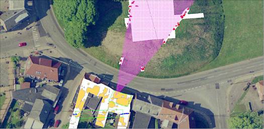
- The area south of the South Mound with the previous excavations marked. The planned excavation areas are marked with green lines. A dotted black line shows the estimated course of the palisade, whilst the southern end of the ship-setting is marked in violet.

Project coordinator: Museum Inspector Steen Wulff Andersen, Vejle Museum.