 |
- Steering group and management
- Sub-projects
- Jelling in GIS (Geographic Information System)
- Geophysical survey at Jelling
- Fieldwork 2011
- Archaeological fieldwork 2010
- Archaeological fieldwork 2009
- Jelling’s large stones
- The landscape around Jelling
- Place names in Jelling and its vicinity
- The bridge over Ravning Enge
- The travertine churches of East Jutland.
- Rune stones in context 2011
- Power and coins 2009
- Exhibitions
- Digitizing the photographs
North of Jelling churchyard
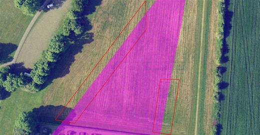
- The area just north of the churchyard at Jelling. The outline of the supposed ship-setting is shown in purple; in red are the planned excavation areas.

The area just north of the churchyard at Jelling. The outline of the supposed ship-setting is shown in purple; in red are the planned excavation areas.
In 2006 and 2007 Vejle Museum undertook a number of investigations in the field north of the churchyard at Jelling, involving both north-south orientated trial trenches and areas of surface stripping. In the course of the excavations a number of large stones appeared, which were later interpreted as the northern tip of a huge stone-setting, with the North Mound at its centre and the southern tip located south of Gormsgade. However, the 2010 excavation south of this street failed to identify any evidence of large stones.
The planned excavations for 2011 – two c.10 m wide areas west and east of the supposed ship-setting – cover areas that have only been partially investigated before. The aim of the new excavations is to examine whether there are sunken down stones or traces of stones present that have not previously been recorded. At the same time the width of the excavation areas will enable investigation of whether there are traces of other types of archaeological features present in this area within the northern half of the Viking Age palisade structure. The excavation work is expected to begin in March.
Project coordinator: Museum Inspector Steen Wulff Andersen, Vejle Museum.
Read more about the supposed ship-setting in the article (in Danish) ’Bautasten og kæmpehegn’ by Steen Wulff Andersen in Skalk 2009 nr. 1.