|
- Steering group and management
- Sub-projects
- Jelling in GIS (Geographic Information System)
- Geophysical survey at Jelling
- Fieldwork 2011
- Archaeological fieldwork 2010
- Archaeological fieldwork 2009
- Jelling’s large stones
- The landscape around Jelling
- Place names in Jelling and its vicinity
- The bridge over Ravning Enge
- The travertine churches of East Jutland.
- Rune stones in context 2011
- Power and coins 2009
- Exhibitions
- Digitizing the photographs
Jelling in GIS (Geographic Information System)
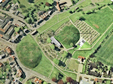
Countless people and institutions have been interested in Jelling over the years. Today a comprehensive documentation of the monuments exists, together with numerous archaeological and historical accounts of the surrounding area’s development from prehistoric to more recent times. Access to the early documentation is an important basis for the Jelling Project, but at the same time the project itself will also generate quantities of new knowledge, to add to that which exists already.
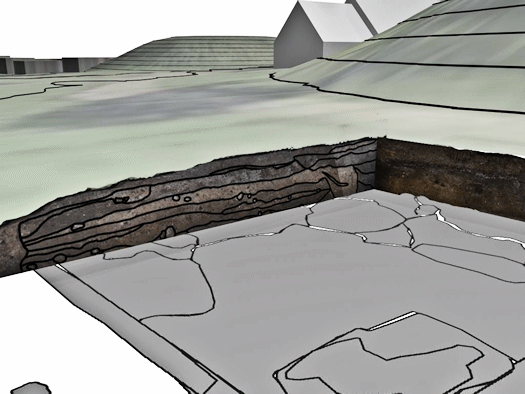
- Sections from the excavation at Thyras Have in 2009 recorded in GIS, in the background is Jelling Church between the two mounds. Peter Jensen, Aarhus University.
GIS
In recent years IT techniques have been used to an increasing degree to document archaeological investigations and handle cultural geographic data. One of the objectives of the Jelling Project is to build up a Geographic Information System (GIS), which can integrate and handle the large amount of different spatial data from Jelling. This includes documentation from previous archaeological excavations, information about the physical landscape, historical map material, as well as photographs of the monuments and the town through time. The Jelling Project also aims to make these available for research and communication to a wider audience. The system can at the same time be used for the recording of new data from the archaeological, cultural geographic and natural science investigations in the coming years.
The sub-project has two main perspectives. Firstly, it will gather and make accessible a large amount of data, which has not previously been practically available, for the research and publicity work of the Jelling Project. This will utilise a number of powerful visual and analytical tools. Secondly, the sub-project will introduce a new technological framework for excavation documentation and landscape analysis in and around Jelling. The level of detail will be high and it will be easier to handle the large amounts of complex data. This will provide new possibilities for processing for interpretation of the archaeological and landscape data.
Project coordinator: Assistant Professor Mads Kähler Holst and Peter Jensen (MA), Aarhus University.