 |
- Steering group and management
- Sub-projects
- Jelling in GIS (Geographic Information System)
- Geophysical survey at Jelling
- Fieldwork 2011
- Archaeological fieldwork 2010
- Archaeological fieldwork 2009
- Jelling’s large stones
- The landscape around Jelling
- Place names in Jelling and its vicinity
- The bridge over Ravning Enge
- The travertine churches of East Jutland.
- Rune stones in context 2011
- Power and coins 2009
- Exhibitions
- Digitizing the photographs
The bridge over Ravning Enge
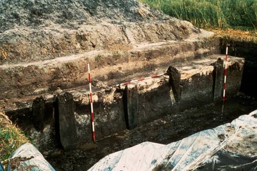
- A complete pier consisted of four vertical posts with a sloping supporting post on each side. Photo: the National Museum.

Around 980 a huge bridge was built over Ravning Enge (Ravning Meadows) at one of the widest parts of the River Vejle valley. The bridge’s existence has been known about since the 1930s, when posts appeared during ditch digging in the meadows. In 1953 restructuring work on the River Vejle and the draining of the meadows led to the discovery of several posts on the south side of the river valley at Vork. The tops of the posts gradually stuck up as the turf layers sank down as a result of the drainage work. Others appeared during the construction of a fish farm in 1956, also on the Vork side of the river. Corresponding posts were found on the north side of the river valley.
In 1972 the National Museum began excavations at the location, which lasted until Museum Inspector Thorkild Ramskou’s death in 1982. Work was resumed in 1993 by Museum Inspector Mogens Schou-Jørgensen, of the Keeper of National Antiquities’ Archaeological Secretariat at the National Museum, based upon Ramskou’s records of the bridge. The new investigations consisted mostly of inspection work, mainly based upon borehole profiles and surveys, but new archaeological excavations were also carried out. Attention was placed upon the bridge abutments and their immediate surroundings, the earlier defensive site of Troldborg Ring and some low-lying defensive remains on the river valley’s north side. In 1995-96, during the rearrangement of a fish farm area, which partly covered the bridge’s northernmost abutment and the first pier, additional new material appeared, more specifically parts of the bridge’s superstructure. Various scientific analyses were undertaken in connection with the investigations, including geophysical survey, geological analysis and new dendrochronological measurements of the preserved wood.
The objective of the project
Information about the first discoveries from Ravning Enge was published in Vejle County Council’s Yearbook of 1959, and since then various articles have been published about the bridge. The project aims to produce a complete scholarly publication about the excavations and natural science investigations, and is the result of a combined funding between the Jelling Project, the Department of Danish Prehistory at the National Museum and Farumgaardfonden.
The bridge is an impressive structure from the end of Harald Bluetooth’s lifetime, and with a location only 10 km south of Jelling it is natural to link Jelling and Ravning Enge together. Its size, the amount of timber used and manpower involved indicate that the bridge was built by the major power of that time. As it is closely contemporary with the Viking Age geometric ring fortresses in Denmark (Trelleborg on Zealand, Fyrkat and Aggersborg in Jutland, and Nonnebakken on Funen) it is natural to interpret the Ravning bridge, and perhaps other smaller contemporary bridges, as an important part of the political and military activity around the year 980.
Project coordinator: Museum Curator Dr Peter Pentz, Department of Danish Prehistory, the National Museum.
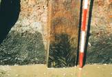
- A modern measuring pole placed alongside a bridge post displaying traces of axe strokes. Photo: the National Museum.
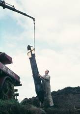
- One of the bridge posts is pulled up with mechanical help. Photo: the National Museum.

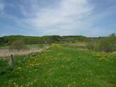
- A covering of earth protects the bridge’s course over Ravning Enge, May 2010. Photo: the National Museum.

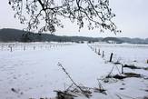
- Ravning Enge. Photo: the National Museum.

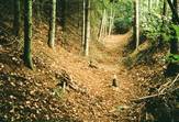
- Hollow way in the wood on the north side of the bridge. Photo: the National Museum.
