- Steering group and management
- Sub-projects
- Jelling in GIS (Geographic Information System)
- Geophysical survey at Jelling
- Fieldwork 2011
- Archaeological fieldwork 2010
- Archaeological fieldwork 2009
- Jelling’s large stones
- The landscape around Jelling
- Place names in Jelling and its vicinity
- The bridge over Ravning Enge
- The travertine churches of East Jutland.
- Rune stones in context 2011
- Power and coins 2009
- Exhibitions
- Digitizing the photographs
Electromagnetic survey at Jelling in 2008
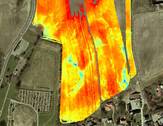
In the autumn of 2008 the area of the magnetometer survey at Jelling was extended. Electromagnetic measurements were taken in the fields between the monuments and “the Many Mounds” to the north to establish whether there were also traces of activity here.
The method is based on the fact that different types of ground have various degrees of conductivity. Variations in the conductivity are measured with the help of a sensor, which is moved over the ground surface. A transmitter pole sends out a magnetic field and a secondary magnetic field is created in the ground. A receiving pole records the combined magnetic field and by subtracting the known primary field from the combined reading the ground’s relative electrical conductivity can be established. Variations in the conductivity can point towards human intrusion into the ground and with this help identify cultural traces, such as levelled burial mounds, demolished buildings, fence lines or filled up ponds. These can subsequently be investigated more closely.
Project participants: Mogen H. Greve, Søren B. Torp og Henrik Nørgård, Faculty of Agricultural Sciences, Aarhus University.


