 |
- Steering group and management
- Sub-projects
- Jelling in GIS (Geographic Information System)
- Geophysical survey at Jelling
- Fieldwork 2011
- Archaeological fieldwork 2010
- Archaeological fieldwork 2009
- Jelling’s large stones
- The landscape around Jelling
- Place names in Jelling and its vicinity
- The bridge over Ravning Enge
- The travertine churches of East Jutland.
- Rune stones in context 2011
- Power and coins 2009
- Exhibitions
- Digitizing the photographs
West of Jelling churchyard
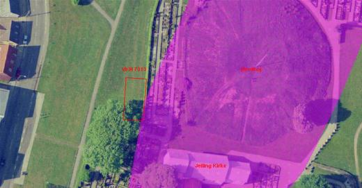
- The area north of Jelling Church. The possible excavation area is marked with a red rectangle.

In 1964-65 Museum Inspector Olfert Voss of the National Museum undertook an investigation of the area immediately west of the North Mound at Jelling, both west of the hedge forming the churchyard’s western boundary and inside the churchyard.
During these excavations several large stones were uncovered, together with archaeological features, which were interpreted as traces of stones, possibly associated with a large ship-setting. Until now it has not been possible to accurately locate the excavation plans of 1964-65 geographically. The aim of the resumed excavation, planned for the early spring of 2011, is to expose parts of the old excavation areas and re-find some of the recorded archaeological features.
A rectangular excavation area of c.18 x 9 m will be laid out immediately west of the churchyard. This is expected to produce measuring points to enable more precise location of the earlier excavations and thus help integrate the earlier excavation material into the general records from the Jelling monuments area. At the same time the investigation will include detailed studies of the records of the different fills, which supplement the photographs and drawings from the excavations of 1964-65. In general the investigation forms part of the examination of the theory of a large ship-setting with the North Mound located at its centre.
Project coordinator: Museum Inspector Steen Wulff Andersen, Vejle Museum.
Read more about the supposed ship-setting in the article (in Danish) ’Bautasten og kæmpehegn’ by Steen Wulff Andersen in Skalk 2009 nr. 1.